

Nearly everything went wrong on this activation, but it was also one of my best SOTA experiences.
This peak is right above a defunct copper mine that was last operated commercially in the 1970s. The blue-green water that fills the pit is visible on aerial photographs.
The road leading by the site is about 45 minutes from Nicosia and I reasoned that at one time trucks had made it up to almost the top of the mountain, so it should be accessible by road. It turns out that is only partially correct.
Neither aerial photos nor topographic maps were entirely reliable for this activation. For example, the quarry is not really a distinguishable feature on the topo maps, and the vertical relief of the area mostly fall between the contour lines of maps; further, none of the topo maps show paths or roads around the site.

I based my approach on the GoogleMaps aerial photo: I planned to take the red path above. Note that photo is oriented South-up. The pin marks the turn off from the main road, and GoogleMaps was fine to get me to that point. In the direction that I was traveling down from Nicosia, that turn would have been very sharp. There is a grassy area on the opposite side of the road, though, can be used to turn the car around. From that turn onward, the road is dirt, or as it is now rainy season, mud. The road leads eventually to the buildings seen above. The lower one is actually a fenced area with solar panels and the upper is a house. On the photo, it appears that a road that wraps around behind the house and continues upward, but when I got there all I saw was a private driveway next to the house.
I didn’t want to drive through private property, so I parked the car some distance away and scouted up the driveway where the road should have been. There’s a large metal tank on top of the hill where the road goes from road to, essentially, a grass-covered path.

Opposite the tank is this sign (which I later learned is often ignored by trespassing hunters, as is evidenced by shotgun shells scattered here and there on the way to the peak):

While the car could have made it up this path, it is good that I did not, as I noticed some irrigations lines crossing the path, and I think they would have been damaged by cars passing by.

So, cross that road off the map (the lower arc with green x’s through it).
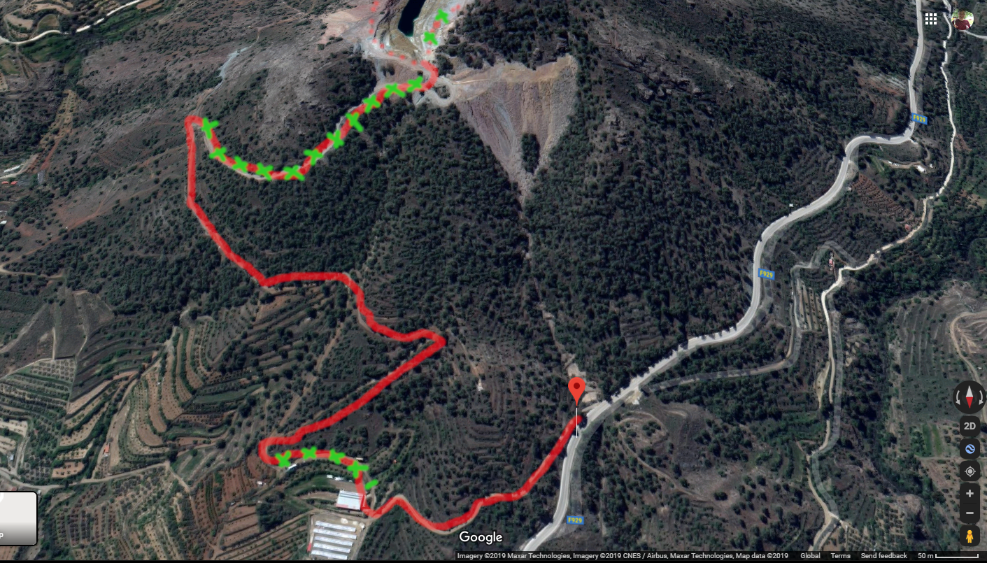
I continued to the point that the road turned upward and from there out, it looked like there was a dirt road upwards in reasonable condition. Instead of going up, I turned back downhill and eventually come to another mud road that lead back between the solar collectors and the house.
I had parked the car in a field just below the fenced solar collector area (marked “P” on the map at the bottom of this post) and on the way back, I waved to a man within the fence. He waved back and we had a brief chat about the best way up the hill. He told me it could best be explained over a cup of coffee and invited me to join him in his house.
A cup of coffee and a few shots of some excellent walnut-infused zivania later, and I not only had some instructions about how to get to the top, but had learned a little about the history of the area and about my host and his family.
Concerning the way up to the top, he informed me that some time after the mine had ceased commercial operation, the town decided to close the road connecting his property with a highway to the south. That had been the main truck route up to that point, leaving him the smaller dirt road that I had come in on as his main access. After that, the path through his property to the mine area was no longer maintained. However, he informed me that it would be possible to drive along the mud road between the house and solar collectors and then turn right and upward. Past that point, a portion of the road towards the summit is still good up to the hairpin turn in the road. From there, the road is deeply fissured (indicated by more green x’s on the photo above), so it would be necessary to go on foot.
Before I set out again, my host and his wife invited me for a post-SOTA dinner back at their house.

I drove up to the hairpin and parked. The road appears to continue both east and west from here.


From that hairpin turn area, there is a great view of the town, Xiliatos, below. A second quarry near the town now serves as a lake, with a nearby river dammed off to supply water.

Looking at maps linked to the SOTA page for Summit 5B/CY-038, it looked like the eastern approach would be the most direct, so I set off on foot that way. What I should have done, I now believe, was to have continue past the hairpin on the road. More on that in a bit.

The eastern spur continues as a road for a short distance and then narrows to a path.


The path turns right at a small fenced area. Soon it is just a grassy footpath, if that.

I continued to follow the trail, looking for a both a way to higher ground and for meaty red mushrooms that the family at the bottom of the hill had mentioned might be in season. I didn’t see many promising ways up, nor many mushrooms.

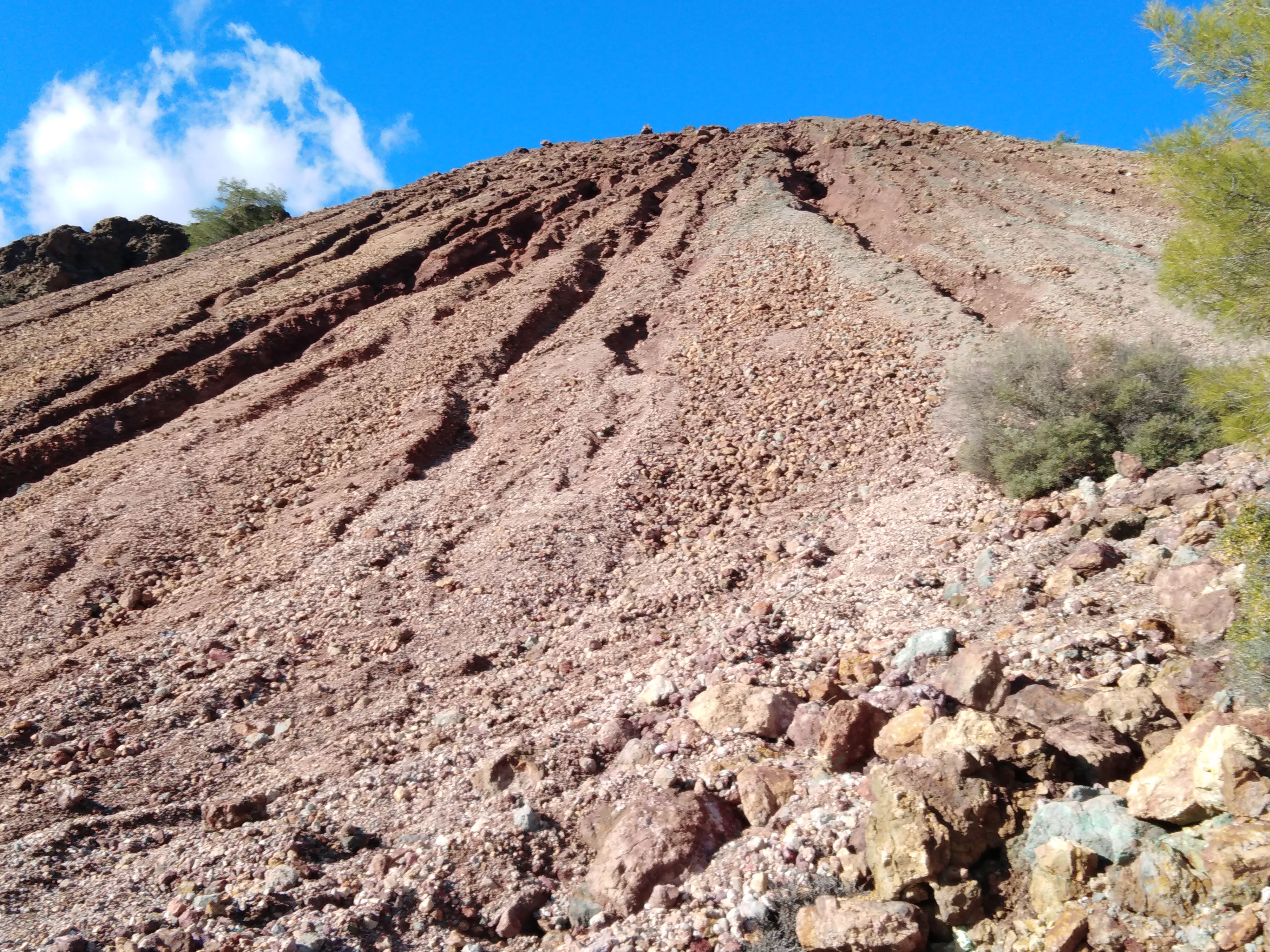
The higher ground along much of the path was just rockslides and loose dirt without any promise of a handhold.
At one point, the trail started losing altitude and I reckoned that I was north of the peak and had gone too far. I backtracked to an area where at least a few trees grew on the hill and there were larger boulders that might afford handholds on the way up.

I would not have taken this route in the summer, when I would have to worry about snakes hanging out in so many of the convenient crevices into which I was blithely sticking my hands and feet on the way up. This is probably the closest I have come to technical mountain climbing on a SOTA activation, and since I was not particularly equipped for it, I was at the limit of what I wanted to attempt on a the side of a remote hill by myself.
So, I took it slow on the way up and had time to take a good look at the rocks — this site is a geologists dream. My host had mentioned that occasionally groups of geologists show up, go up the mountain, and come down hours later. I’m not sure that photos will convey the diversity of colors and textures present, but here are a few. Some of the rocks clearly have metallic veins in them and felt very dense when I picked them up.


I pushed on for the last couple meters, scrambling up the loose rock — I was so close to the top I could taste it. Nothing above me but blue sky.
Until I got to the top and realized that I had just made it up to the road that goes around the eastern edge of the quarry. Across the water-filled pit from me: the actual peak, still quite a ways up, but clearly not climbable from this approach.

I continued northward on the trail to try to find a better way up.

The top of that trail empties out on a plateau.

The northern most edge is a sheer drop.

The most promising way up from the plateau looked like it would be near a bunch of pine trees, which grow where the path meets the plateau.

The rock formation behind the pine tree is sloped and has handholds, so I was able to make my way up it with some effort. I could only get about midway up, though. At that point, I reasoned that I was within the activation zone.

I had to go down and up again to get the end-fed antenna strung between some pine trees. This is one of the few activations where the feed end of the antenna ended up higher than the distant end.
When I reached for the feed line — surprise — there was no feed line. Ah yes, it would be back in the car with the BuddiPole equipment that I had decided not to lug with me.
So, there I was, hanging onto the side of a rock formation with the gear laying on a narrow edge and one hand holding the end of my antenna, but no coax. My QRP kit is kind of minimal, but I do bring along a few items that have helped me deal with this sort of calamity: alligator clips, duct tape, and a leatherman multitool.
I suspended the end of my end-fed antenna with string, only centimeters from my FT817. I bashed one of the alligator clips enough to make it fit in the inner-conductor hole of the rig’s rear SO-239 socket. I had to use some of the stranded copper wire from my battery connection to twist some strands into a thin enough braid to shove into the bayonet hole in the antenna’s BNC jack. Duct tape held that otherwise tenuous connection in place. The other wire clipped from the metallic back of the FT817 to the BNC shield. Not that it probably helped much, but I twisted the two alligator clip wires around each other for “shielding”.
I was amazed this worked at all. I got about half the bars on the FT817’s SWR meter but no warning and no fold-back in output power. I suspect the only reason this worked at all is down to the broad matching network at the base of the end-fed antenna.
I didn’t expect to work anyone at this point, not only was the connection jury rigged, but he antenna was shielded by a rock wall to the west. However — never underestimate the keen ears of SOTA operators. Whatever puny signal I was putting out didn’t make a dent in the reverse beacon network, but I was picked up by UA2PDT, SA4BLM, 9A1AA, and SM5LNE. My final contact was a near ESP-level QSO with EA2DT (sent: 219, received 339). I briefly tried 40 meters, but heard nothing. I figured I had pushed luck far enough, so I disassembled my flimsy antenna connection, packed up, and worked my way back down to the plateau.

Looking northward from there, there is an isolated mound at the other end of the quarry, and another path spirals up it to a platform at top. This feature was not obvious on any of my topographic maps. I was later told that this mound had once served as an artillery emplacement. I believe that the saddle between the top of that mound and the summit would place that site outside the activation zone, but otherwise it would be a nice place to operate. Here is a closer look at it:

Spinning around 180 degrees from that emplacement, I could look back towards the quarry, along the way that I had come:

The sun was getting lower at this point in the afternoon, but I wanted to see if there was an easier way down. I followed the level road westward past the emplacement and realized that there is a back side to this summit.

The road runs north again, this time on the west side of the summit, which has much better tree cover. There is still a lot of loose rock and gravel on this side, so it may be more difficult to scale than it looks, but it appears that this would be a much more reasonable way to approach the summit. Working up along the trees, it may be possible to reach the ridge and then walk northwards to the highest point.

The road on this side of the mountain turns downward, curving back and forth. There are some meter-plus deep furrows in the road, large boulders and eroded areas. I would not risk driving my car up this part of the road, but it certainly would be the way to come on foot next time.

Eventually, as expected, the road led back to the hairpin curve where I had parked, and I was able to drive back down.
When I reached the house, it was just about dark out. I knocked on the door and was invited in for an excellent dinner, a bit more zivania, and wine produced right from the land next to the house — Cypriot hospitality at its finest!
So, to summarize, here’s what I learned today in terms of reaching the summit (see below). DO NOT: take the wrong road, unnecessarily scramble up a wall of loose rock, scale another rock wall, and leave your fee dline in the car. DO: Approach on the yellow road, up to the hairpin turn on the mountain road. Then, make that sharp turn and walk up the road towards the summit. To the east will be the artillery emplacement (E) mound. I recommend that you do not follow today’s path (yellow dots) towards the southern end of the mine (M), but rather go west at the emplacement to the “rear” of the mountain and look for a way up to the ridge from that more gently sloped and better forested side.
