
Blue Mountain
This is as drive-up a SOTA site as every there was one; the only thing that would make it easier would be if it were in my backyard.
This site is west and south of Washington DC, a drive out along interstate 66 towards Front Royal. I-66 is my regional nemesis, with frequent backups and huge tolls within the beltway, but heading west in the morning and back east in the afternoon is contrary to the usual traffic flow, so the trip isn’t too bad. This site is just marginally closer to DC than the sites that are found within Shenandoah National Park proper.
This site is located at the head of the Trillium trail, which runs southwards and connects to the Appalachian Trail. The parking lot itself is within the activation zone, but if you feel like you need to walk a bit to justify the activation, the trail is right there and you can walk as far as you’d like (although it’s pretty flat for some distance).

The activation zone for the W4V association is 25m, and the summit is 674m, so the parking lot at the junction of route 638 and the Trillium trail, shown above, is definitely within the 650m contour.
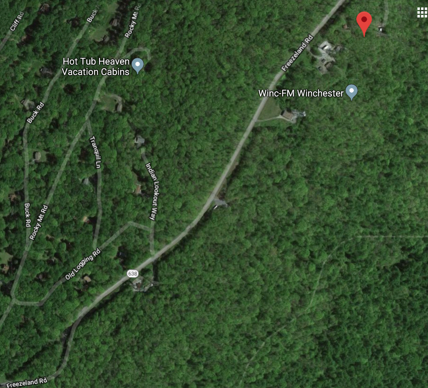
Here’s the same area in Google Maps, with the parking area (38.957981, -78.023448) centered. It looks like there was a semi trailer parked there the day the aerial photo was acquired. Note the commercial antenna farms both north and south along route 638. I had some elevated background noise on 30m, but other bands were fine.
There are plenty of tall trees near the parking lot, so I tossed an end-fed into one of them and worked 40m and 20. I also deployed a small magnetic loop antenna to give 30m and 17m a try.
While I was operating a couple cars pulled in briefly, probably confused to see someone in a heavy winter jacket sitting placidly in a bright turquoise lawn chair and staring out into the distance while the wind whipped around. My fingers were entirely numb by the end of this activation.

Regarding access to this site, I think if you’re just within the parking lot, you probably don’t need to do anything in particular. If you take the trail, though, you’ll need to register for some kind of access permit. If you already have a hunting or fishing permit you are covered, but if not, it’s not difficult to register online. I gave it a try and paid $4.00 via credit card using my smart phone to register for a one-day pass. That’s what I’d pay for a one hour parking spot in DC, so I just thought of it as a parking fee.
If you’re trekking into the woods at certain times of the year, it would be good to keep in mind that this is a hunting area.

I had three S2S contacts while here: WX4TM on W4C/CM-023 and both NV4G and KM4JM on W4C/CM-082. I’ve seen a lot of activations lately in the Carolinas Association, probably due to both propagation and it being a bit warmer down there. In a switch around, I worked KX0R, who I’ve frequency chased over the last few months.
Here’s the full log:
| 20:00z | K0RS | 14MHz | CW | s579 r569 |
| 20:01z | W5BOS | 14MHz | CW | s579 r539 |
| 20:02z | K6HPX | 14MHz | CW | s579 r529 |
| 20:03z | N6PKT | 14MHz | CW | s569 r529 |
| 20:04z | W4KRN | 14MHz | CW | s579 r569 |
| 20:05z | NS7P | 14MHz | CW | s559 r559 |
| 20:20z | K2JB | 7MHz | CW | s589 r559 |
| 20:22z | K9IR | 7MHz | CW | s579 r229 |
| 20:23z | WC0Y | 7MHz | CW | s599 r579 |
| 20:24z | W9MRH | 7MHz | CW | s579 r559 |
| 20:24z | KD1CT | 7MHz | CW | s559 r559 |
| 20:25z | AC1Z | 7MHz | CW | s559 r559 |
| 20:27z | WA2USA | 7MHz | CW | s559 r339 |
| 20:28z | N2AF | 7MHz | CW | s559 r559 |
| 20:29z | AD0YM | 7MHz | CW | s569 r339 |
| 20:31z | K0HNC | 7MHz | CW | s449 r229 |
| 20:35z | K3TCU | 7MHz | CW | s339 r229 |
| 20:49z | AE7AP | 18MHz | CW | s579 r339 |
| 20:51z | KX0R | 18MHz | CW | s579 r339 |
| 20:55z | KB9ENS | 10MHz | CW | s599 r339 |
| 20:58z | KX0R | 10MHz | CW | s579 r229 |
| 21:01z | K0LAF | 10MHz | CW | s599 r539 |